
Marble Canyon Arizona & Lees Ferry Travel Guide
Reviewed and updated by AZ Leisure Staff Writers on .
Marble Canyon & The Beginning Of Grand Canyon
Marble Canyon, Arizona is a dramatic Colorado River destination centered around Lees Ferry, Navajo Bridge and the northeastern beginning of Grand Canyon. The area is known for towering canyon walls, cold clear river water, rainbow trout fishing, Grand Canyon rafting launches, kayaking, photography and scenic drives through the Vermilion Cliffs region.
Grand Canyon begins at Lees Ferry, where river mile 0 is measured for trips downstream. Marble Canyon extends downstream through the upper Grand Canyon toward the Little Colorado River confluence. Upstream from Lees Ferry, approximately 15 miles of comparatively smooth Colorado River water extends through Glen Canyon toward Glen Canyon Dam.
Located about 42 miles from Page, Arizona, Marble Canyon is also convenient to Lake Powell, Horseshoe Bend, Glen Canyon Dam and the Vermilion Cliffs, making it an excellent stop on a northern Arizona road trip.
- Marble Canyon Quick Facts
- Things To Do
- Lees Ferry
- Navajo Bridge
- Fishing
- Boating & Rafting
- Best Time To Visit
- Directions
- Map
- Where To Stay
- Travel Tips
- FAQ
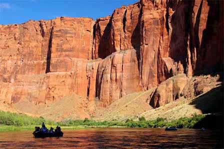 Colorado River Through Marble Canyon. © Silver Spur Tours
Marble Canyon Arizona Quick Facts
- Location: Northern Arizona along US Highway 89A
- Primary river access: Lees Ferry
- Distance from Page: Approximately 42 miles
- Grand Canyon river mile: Lees Ferry is river mile 0
- Colorado River access: Public boat launch at Lees Ferry
- Upstream boating: Approximately 15 miles of smooth water toward Glen Canyon Dam
- Downstream travel: Grand Canyon river trips and whitewater
- Fishing: Renowned rainbow trout fishing upstream from Lees Ferry
- Major landmark: Historic Navajo Bridge
- Visitor information: Navajo Bridge Interpretive Center
- Nearby attractions: Vermilion Cliffs, Page, Lake Powell and Horseshoe Bend
Why Visit Marble Canyon
Visitors come to Marble Canyon for its striking Colorado River scenery, peaceful desert atmosphere, historic river access, excellent fishing near Lees Ferry, and easy access to some of Northern Arizona’s most memorable landmarks. Whether you are planning a fishing trip, river launch, scenic drive, photography stop, or Grand Canyon-area road trip, Marble Canyon offers a quieter and more rugged experience than many busier Arizona destinations.
Things To Do & See Around Marble Canyon
- Lees Ferry: Visit the historic Colorado River crossing and popular launch point for Grand Canyon river trips.
- Navajo Bridge: Walk across the historic pedestrian bridge for dramatic views of the Colorado River approximately 467 feet below.
- Colorado River Views: Enjoy scenic overlooks, photography stops, and river access near Marble Canyon and Lees Ferry.
- Vermilion Cliffs: Take in the colorful cliffs and desert scenery surrounding the Marble Canyon area.
- Historic Sites: Explore the history of Lees Ferry, early river crossings, and settlement along the Colorado River.
- Scenic Drives: Drive U.S. 89A through dramatic Northern Arizona landscapes between Page, Bitter Springs, and Marble Canyon.
- Photography: Capture canyon walls, river bends, desert light, Navajo Bridge, and Colorado River scenery.
- Nearby Page Attractions: Combine Marble Canyon with Lake Powell, Glen Canyon Dam, Horseshoe Bend, and Page Arizona.
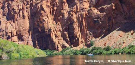
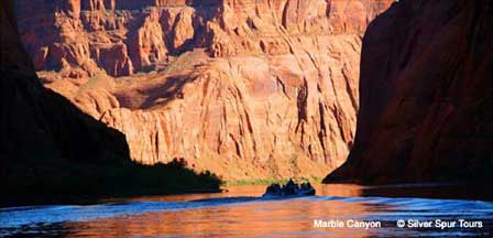
The Colorado River creates a striking contrast with the red, tan and gray cliffs of Marble Canyon. Views from Navajo Bridge, Lees Ferry and US Highway 89A reveal a rugged transition between Glen Canyon and the deeper Grand Canyon downstream, with exceptional scenery for photographers, anglers, paddlers and road-trip travelers.
Fishing At Marble Canyon & Lees Ferry
- Rainbow Trout: The Colorado River upstream from Lees Ferry is nationally known for rainbow trout fishing.
- Cold Clear Water: Releases from Glen Canyon Dam maintain cold-water habitat through the Lees Ferry reach.
- Shore & Wading Access: Fishing is available from accessible river areas near Lees Ferry, subject to current water conditions.
- Boat Fishing: Local outfitters offer guided fishing trips on the Colorado River.
- Fishing License: Anglers must carry a valid Arizona fishing license and follow current Arizona Game and Fish regulations.
- Check Regulations: Fishing rules, limits and tackle restrictions can change, so review current regulations before fishing.
Boating, Kayaking & Rafting At Lees Ferry
Lees Ferry is the principal public Colorado River launch point in the Marble Canyon area. The boat ramp sits at the boundary between Glen Canyon National Recreation Area and Grand Canyon National Park.
- Upstream Boating: Approximately 15 miles of smooth water extends upstream from Lees Ferry toward Glen Canyon Dam.
- Kayaking: Kayakers can paddle upstream or use commercial backhaul services to begin a downstream paddle through Glen Canyon.
- Grand Canyon Rafting: Commercial and permitted private Grand Canyon river trips launch downstream from Lees Ferry.
- Public Boat Ramp: Lees Ferry provides a paved launch ramp with parking and boat-trailer access.
- River Permits: Permit requirements depend on the type and direction of river trip. Grand Canyon river trips require appropriate National Park Service authorization.
- Cold Water: Colorado River water remains cold year-round; wear appropriate personal flotation and safety equipment.
Best Time To Visit Marble Canyon
- Spring: Comfortable temperatures make spring excellent for fishing, hiking, scenic drives and photography, although strong winds are possible.
- Summer: River trips are popular, but extreme heat is common and temperatures can exceed 100°F. Carry abundant drinking water and limit strenuous midday activity.
- Fall: Often one of the most comfortable seasons for fishing, sightseeing, hiking and canyon photography.
- Winter: Visitor numbers are generally lower, but nights can fall below freezing even when daytime conditions are pleasant.
Lees Ferry & Marble Canyon
Lees Ferry is one of the most historically and recreationally important locations on the Colorado River. It was once a vital crossing between Arizona and Utah and today serves as the principal launch point for Grand Canyon river trips, a major trout-fishing destination and the only developed vehicle access to the river in this portion of canyon country.
The Lees Ferry park entrance is in Marble Canyon just west of Navajo Bridge. From US Highway 89A, a paved road travels approximately five miles to the river, historic district, campground and public boat launch.
Navajo Bridge
Navajo Bridge crosses Marble Canyon about five miles downstream from Lees Ferry. The original steel-arch bridge opened to traffic in 1929 and was replaced by a wider parallel highway bridge in 1995.
The historic 1929 bridge remains open to pedestrians and provides dramatic views approximately 467 feet down to the Colorado River. The Navajo Bridge Interpretive Center on the west side provides visitor information, exhibits, books and access to the pedestrian bridge.
Lees Ferry takes its name from John D. Lee, who established ferry operations at this natural Colorado River crossing in the nineteenth century. The crossing became an important transportation link between Arizona and Utah before automobile traffic made a bridge necessary.
The ferry sank in a fatal accident in June 1928 and was not replaced because the first Navajo Bridge was nearing completion five miles downstream. That bridge opened in January 1929, permanently replacing the ferry as the area's principal highway crossing.
Marble Canyon Travel Tips
- Bring Water: Desert conditions can be dry and exposed, especially during warm weather.
- Check River Conditions: River flows, launch rules, and fishing regulations can change.
- Plan Fuel Stops: Services are limited between Page, Marble Canyon, Lees Ferry, and surrounding highways.
- Use Sun Protection: Shade can be limited near overlooks, river access points, and desert trails.
- Allow Extra Time: Nearby attractions such as Navajo Bridge, Lees Ferry, and Vermilion Cliffs are worth exploring slowly.
Exploring Marble Canyon By River
River experiences in the Marble Canyon area differ significantly depending on which direction you travel from Lees Ferry. Upstream, boaters and kayakers can explore approximately 15 miles of relatively smooth Colorado River water through Glen Canyon toward Glen Canyon Dam.
Downstream from Lees Ferry, the river enters Grand Canyon National Park and Marble Canyon whitewater. Permitted rafting trips encounter the first Grand Canyon rapids within the upper canyon and continue through increasingly remote terrain.
Along both reaches, visitors experience towering canyon walls, desert springs, beaches, side canyons and extraordinary geology. Archaeological and cultural resources encountered along the river should never be touched, removed or disturbed.
Directions To Marble Canyon & Lees Ferry
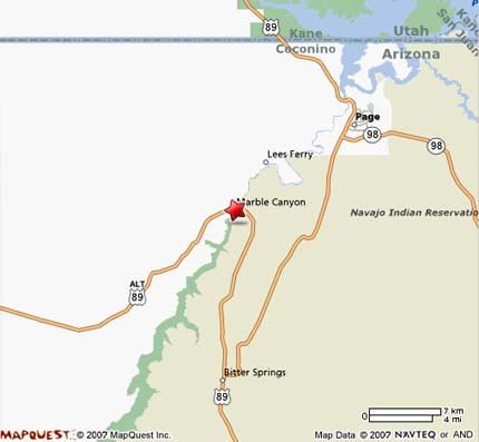
From Page, travel south on US Highway 89 to Bitter Springs, then turn west onto US Highway 89A toward Marble Canyon. Lees Ferry is approximately 42 miles from Page. The park entrance is just west of Navajo Bridge, where a paved road continues approximately five miles to the Colorado River.
From Flagstaff, travel north on US Highway 89 toward Bitter Springs, then continue west on US Highway 89A to Marble Canyon. Driving time is generally about two hours depending on traffic, weather and your starting location.
Page Municipal Airport is the closest commercial aviation facility to the Marble Canyon area. Travelers should arrange ground transportation separately and confirm current rental-car or shuttle availability before arrival.
Marble Canyon Arizona Map
Where To Stay Near Marble Canyon
Travelers can stay directly in the Marble Canyon and Lees Ferry area or use Page as a larger lodging base about 42 miles away. Local options include Marble Canyon Lodge, Cliff Dwellers Lodge and Lees Ferry Lodge at Vermilion Cliffs.
Page offers the widest selection of hotels, restaurants and visitor services, while staying near Marble Canyon provides quicker access to Lees Ferry, Navajo Bridge, fishing, kayaking and Vermilion Cliffs recreation.
Navajo Bridge Interpretive Center
The Navajo Bridge Interpretive Center is located on the west side of Navajo Bridge along US Highway 89A. The center provides visitor information, maps, exhibits, books and access to the historic pedestrian bridge.
Current 2026 NPS information lists the center as open daily from 9:00 AM to 5:00 PM during much of the year, with winter hours generally 9:00 AM to 4:00 PM. Hours and holiday closures can change, so verify current National Park Service information before visiting.
Current 2026 Lees Ferry Update
Campground renovation: The upper loop of Lees Ferry Campground is temporarily closed for renovations through September 30, 2026. Other Lees Ferry visitor facilities remain available, but travelers planning to camp should check current National Park Service alerts before arrival.
Marble Canyon Travel Tips
- Carry plenty of drinking water because summer temperatures can exceed 100°F and shade is limited.
- Check current Colorado River flows, boating rules and fishing regulations before launching or fishing.
- Remember that the smooth-water boating reach is upstream from Lees Ferry; downstream travel enters Grand Canyon whitewater.
- Fill your fuel tank before exploring remote roads because services are limited outside Marble Canyon and Page.
- Use sun protection throughout the year because river and canyon areas are highly exposed.
- Stop at Navajo Bridge and walk the historic pedestrian bridge for one of the best accessible canyon views.
- Allow extra time for Lees Ferry historic sites, the river launch, Navajo Bridge and Vermilion Cliffs scenery.
- Do not disturb archaeological sites, rock art or cultural resources.
- Check current NPS alerts for campground, river, weather and access updates before traveling.
Marble Canyon Arizona FAQ
Where Is Marble Canyon Arizona?
Marble Canyon is located in northern Arizona along US Highway 89A near Lees Ferry and Navajo Bridge, approximately 42 miles from Page.
Where Does Grand Canyon Begin?
Grand Canyon begins at Lees Ferry, which is designated river mile 0 for Colorado River trips through Grand Canyon National Park.
Is Marble Canyon Worth Visiting?
Yes. Marble Canyon is especially worthwhile for Colorado River scenery, Navajo Bridge, Lees Ferry history, trout fishing, rafting, kayaking, photography and access to the Vermilion Cliffs region.
Can You Fish At Marble Canyon?
Yes. The Colorado River upstream from Lees Ferry toward Glen Canyon Dam is well known for rainbow trout fishing. A valid Arizona fishing license and current regulations are required.
Can You Boat At Marble Canyon?
Yes. Lees Ferry provides a public Colorado River boat launch. Approximately 15 miles of smooth water extends upstream toward Glen Canyon Dam, while permitted river trips travel downstream through Grand Canyon.
How Far Is Marble Canyon From Page Arizona?
Lees Ferry and Marble Canyon are approximately 42 miles from Page by US Highway 89 and US Highway 89A.
Can You Walk Across Navajo Bridge?
Yes. The original 1929 Navajo Bridge is preserved as a pedestrian bridge and provides views approximately 467 feet down to the Colorado River.
Is Lees Ferry The Same As Marble Canyon?
Lees Ferry is a historic and recreational Colorado River access site within the broader Marble Canyon area. The entrance to Lees Ferry is along US Highway 89A in Marble Canyon near Navajo Bridge.
What Are The Best Things To See Near Marble Canyon?
Popular nearby attractions include Lees Ferry, Navajo Bridge, Vermilion Cliffs, Page, Glen Canyon Dam, Horseshoe Bend and Lake Powell.
What Is The Best Time To Visit Marble Canyon?
Spring and fall generally provide the most comfortable weather for sightseeing, fishing and outdoor recreation. Summer can be extremely hot, while winter nights may fall below freezing.