
Oak Creek Canyon Directions & Driving Map
Updated by AZ Leisure Staff Writers on
Driving Map From Phoenix, Sedona & Flagstaff
Oak Creek Canyon is located along Arizona State Route 89A between Sedona and Flagstaff. Travelers can reach the canyon from Phoenix by driving north on Interstate 17 and continuing through Sedona, or from Flagstaff by taking SR 89A south through the forested high country and upper-canyon switchbacks.
The officially designated Sedona-Oak Creek Canyon Scenic Road is approximately 15 miles long. Along the route, visitors can reach Oak Creek Vista, West Fork Trail, Slide Rock State Park, Grasshopper Point and several picnic and creek-access areas.
- Oak Creek Canyon Route Quick Facts
- Directions From Phoenix
- Directions From Flagstaff
- Directions From Sedona
- Best Stops Along The Route
- Oak Creek Canyon Map
- Current Road Conditions
- Driving Tips
- FAQ
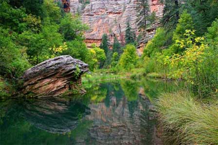 Oak Creek Canyon West Fork Trail. © Mike Koopsen
Oak Creek Canyon Route Quick Facts
- Main highway: Arizona State Route 89A
- Official scenic-road length: Approximately 15 miles
- Between: Sedona and the Flagstaff high country
- From Phoenix: Interstate 17 north, then SR 179 through Sedona to SR 89A
- From Flagstaff: SR 89A south from the I-17/89A junction
- Major stops: Oak Creek Vista, West Fork, Slide Rock State Park and Grasshopper Point
- Road type: Two-lane paved highway with curves, grades and switchbacks
- Winter conditions: Snow and ice can temporarily affect access
- Wildfire conditions: Temporary restrictions can occur during active incidents
- Before driving: Check AZ511 for current conditions
Directions To Oak Creek Canyon From Phoenix
From Phoenix, take Interstate 17 north toward Flagstaff. Leave I-17 at Exit 298 and follow State Route 179 north through the Village of Oak Creek and into Sedona. In Sedona, continue north on State Route 89A to enter Oak Creek Canyon.
The drive from the Phoenix area generally takes a little over two hours without extended stops, although traffic through Sedona can add time during busy weekends and holidays.
Directions To Oak Creek Canyon From Flagstaff
From Flagstaff, travel south on State Route 89A from the Interstate 17 junction near the south side of the city. The route passes through ponderosa-pine forest before reaching Oak Creek Vista and descending into the canyon through a series of switchbacks.
Continue south on SR 89A for access to West Fork Trail, Slide Rock State Park, Grasshopper Point and Sedona.
Directions To Oak Creek Canyon From Sedona
From Uptown Sedona, follow State Route 89A north. The highway enters Oak Creek Canyon almost immediately and continues past Grasshopper Point, Slide Rock State Park and West Fork before climbing the switchbacks to Oak Creek Vista.
The officially designated scenic-road section between Sedona and the upper canyon is approximately 15 miles long.
Best Stops Along The Oak Creek Canyon Route
- Oak Creek Vista: Panoramic overlook near the top of the Highway 89A switchbacks.
- West Fork Trail: Shaded hiking route with repeated creek crossings and excellent fall foliage.
- Slide Rock State Park: Popular swimming and recreation area along Oak Creek.
- Grasshopper Point: Creekside day-use area for picnicking and water recreation when conditions are safe.
- Sedona: Southern gateway to Oak Creek Canyon with red-rock scenery, dining, shopping and lodging.
Oak Creek Canyon Map & Driving Routes
The map shows the primary route from Phoenix through Sedona and Oak Creek Canyon, along with Interstate 17 as an alternate regional route between Phoenix and Flagstaff. Travelers can create a scenic loop by driving through Oak Creek Canyon in one direction and using Interstate 17 for the return trip.
For the most scenic experience, consider driving State Route 89A both northbound and southbound on separate trips because the canyon views differ significantly by direction.

Oak Creek Canyon Road Conditions
State Route 89A is currently open between Sedona and Flagstaff. The highway reopened July 13, 2026 after the Pocket Fire temporarily closed the corridor.
Wildfire response, rockfall, snow, ice, storms and highway work can still cause temporary restrictions or closures. Check current Arizona Department of Transportation conditions through AZ511 before traveling.
Oak Creek Canyon Driving Tips
- Check AZ511 before leaving, especially during winter or wildfire season.
- Use designated parking areas and pullouts rather than stopping on narrow shoulders.
- Allow extra time for traffic near Slide Rock, West Fork and Sedona.
- Use caution on the upper-canyon switchbacks and sharp curves.
- Watch for cyclists, pedestrians and wildlife near recreation areas.
- Expect limited cell-phone reception in parts of the canyon.
- Carry drinking water even when temperatures are cool.
- Do not enter Oak Creek during flash-flood warnings.
- Allow more travel time during snow, monsoon storms and holiday weekends.
- Use Interstate 17 as an alternate route between Flagstaff and Sedona when SR 89A is temporarily closed.
Oak Creek Canyon Directions FAQ
Where Is Oak Creek Canyon Located?
Oak Creek Canyon is located in northern Arizona between Sedona and Flagstaff along State Route 89A.
How Do You Get To Oak Creek Canyon From Phoenix?
From Phoenix, take Interstate 17 north to Exit 298, follow State Route 179 through Sedona, then continue north on State Route 89A into Oak Creek Canyon.
How Do You Get To Oak Creek Canyon From Flagstaff?
From Flagstaff, take State Route 89A south toward Sedona. The highway reaches Oak Creek Vista before descending into Oak Creek Canyon through the upper-canyon switchbacks.
How Far Is Oak Creek Canyon From Sedona?
Oak Creek Canyon begins immediately north of Sedona, and the officially designated Sedona-Oak Creek Canyon Scenic Road is approximately 15 miles long.
How Far Is Oak Creek Canyon From Flagstaff?
The distance from Flagstaff to Sedona through Oak Creek Canyon is roughly 28 miles, with Oak Creek Vista and the upper canyon reached before continuing south toward Sedona.
Is Oak Creek Canyon Scenic Drive Open Now?
State Route 89A is currently open between Sedona and Flagstaff, but conditions can change because of wildfire, snow, ice, rockfall or road work. Check AZ511 before traveling.
Can Oak Creek Canyon Road Close In Winter?
Yes. Snow, ice and hazardous driving conditions can temporarily close or restrict State Route 89A through Oak Creek Canyon.
What Are The Best Stops Along Oak Creek Canyon?
Popular stops include Oak Creek Vista, West Fork Trail, Slide Rock State Park and Grasshopper Point.
What Is The Alternate Route If Highway 89A Is Closed?
The common alternate route between Sedona and Flagstaff uses State Route 179 and Interstate 17.
Can You Drive Oak Creek Canyon In Both Directions?
Yes. State Route 89A can be driven northbound or southbound, and the canyon offers different views depending on direction.
More Oak Creek Canyon & Sedona Information
- Sedona Arizona & Oak Creek Canyon
- Oak Creek Canyon Scenic Drive
- Oak Creek Arizona
- Oak Creek Canyon Photos By Mike Koopsen
- Oak Creek Canyon Vista Overlook
- West Fork Oak Creek Trail
- Slide Rock State Park
- Sedona Weather & Climate
The Wonder Of Sedona & Oak Creek
Sedona-Oak Creek Canyon
Sedona Arizona
Oak Creek Canyon
Arizona Route 66
Map & Directions
Weather & Climate
Sedona Pictures
Things To Do
Sedona Golf Courses
Grand Canyon Tours
West Fork Trail
Desert Canyon Drive
Sedona Museums
Events & Festivals
Horseback Riding
Area Attractions
Palatki Indian Ruins
Montezuma Castle
Montezuma Well
Grand Canyon South Rim
Sycamore Canyon
Slide Rock State Park
Grand Canyon Railway
Chapel of the Holy Cross
Oak Creek
Nearby Towns
Flagstaff Arizona
Jerome Arizona
Cornville Arizona
Williams Arizona
Cottonwood Arizona
Sedona Articles
Native American History
Vortex Visions
Mystical Vortexes
Enchantment Resort
Credit The Sinagua
Where To Stay
Cabins & Lodges
RV Parks & Campgrounds
Bed and Breakfast
Sedona Vacation Rentals
Sedona Timeshares