
Arizona Map of Cities, Regions & Vacation Destinations
Reviewed and updated by AZ Leisure Staff Writers on .
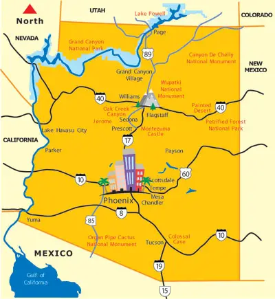
This Arizona map provides a statewide view of major cities, highways, travel regions and popular vacation destinations. Use it to locate Phoenix, Tucson, Flagstaff, Sedona, Yuma, the Grand Canyon, the White Mountains, Colorado River communities and other places throughout the state. Arizona's geography ranges from low-elevation Sonoran Desert valleys to high mountain forests and canyon country, so understanding where destinations are located can make it easier to plan road trips, scenic drives and Arizona vacations.
Use the statewide map below for general orientation, then follow the links to detailed Arizona city, regional, lake, park and destination maps. Additional maps can help with driving routes, distances and trip planning for specific areas of the state.
- Arizona Travel Regions
- Major Arizona Cities
- Geography & Travel
- Arizona City & Regional Maps
- Road Trip Planning
- FAQ
Arizona Travel Regions
Arizona can be divided into several broad travel regions, each with different landscapes, elevations, climates and attractions. These regions are useful for organizing road trips and choosing destinations by season.
- Northern Arizona: Grand Canyon, Flagstaff, Sedona, Page, Lake Powell, Route 66 communities and high-elevation forests
- Central Arizona: Phoenix, Scottsdale, Mesa, desert parks, resorts and recreational lakes
- Southern Arizona: Tucson, Tombstone, Bisbee, Nogales, Sonoran Desert scenery and historic attractions
- Eastern Arizona: White Mountains, Show Low, Pinetop-Lakeside, Greer, alpine forests and mountain lakes
- Western Arizona: Yuma, Lake Havasu City, Parker, Bullhead City and Colorado River recreation areas
Northern Arizona is especially popular for mountain and canyon scenery, while the Phoenix metropolitan area anchors Central Arizona. Southern Arizona offers desert and historic destinations, and the White Mountains provide some of Arizona's highest-elevation recreation areas.
Major Cities On The Arizona Map
Arizona's major cities are spread across desert valleys, mountain regions and historic travel corridors. They provide useful starting points for lodging, road trips and nearby attractions.
- Phoenix: Arizona's capital and largest metropolitan area, with resorts, desert parks, golf, dining and nearby lakes
- Tucson: Southern Arizona's largest city, surrounded by Sonoran Desert landscapes, historic sites and mountain ranges
- Flagstaff: A high-elevation Northern Arizona city near the Grand Canyon, Route 66, pine forests and winter recreation
- Sedona: A red-rock destination known for hiking, scenic drives, galleries and Oak Creek Canyon
- Prescott: A historic Central Arizona city surrounded by mountains, forests and recreational lakes
- Yuma: A southwestern Arizona city near the Colorado River, California and Mexico borders
- Lake Havasu City: A western Arizona destination on the Colorado River known for boating and lake recreation
- Show Low & Pinetop-Lakeside: White Mountains communities popular for cooler summers, lakes and outdoor recreation
How Arizona's Geography Shapes Travel
Arizona's elevation and landscape change dramatically from the low deserts of the southwest to high plateaus and mountain ranges in the north and east. These geographic differences affect temperatures, seasonal travel, road conditions and the types of outdoor recreation available in each region.
- Desert Regions: Central and southern Arizona are popular for winter travel, spring wildflowers, hiking, golf and desert sightseeing
- Mountain Regions: Northern and eastern Arizona offer forests, lakes, cooler summers, snow recreation and scenic mountain drives
- Canyon Country: Northern Arizona includes the Grand Canyon, Marble Canyon, Canyon de Chelly and other dramatic landscapes
- Lake & River Areas: Western Arizona and several mountain regions provide boating, fishing, kayaking and other water recreation
Arizona City, Regional & Destination Maps
Use the links below to find detailed Arizona city maps, regional maps, lake maps, park maps and destination maps. Arizona Leisure maps may be used for personal and educational purposes. Commercial usage requires prior approval. Contact us for additional information.
- Apache Trail Map
- Arizona Distance Guide
- Arizona Lakes Map
- Arizona Parks Map
- Canyon de Chelly Map
- Chandler Area Map
- Flagstaff Area Map
- Greater Phoenix Area Map
- Hoover Dam Map
- Lake Havasu City Map
- Lake Powell & Page Area Map
- Mesa Area Map
- Parker Arizona Map
- Payson Arizona Map
- Prescott Arizona Area Map
- Scottsdale Area Map
- Sedona Area Map
- Tempe Area Map
- Tombstone Arizona Area Map
- Tucson Arizona Area Map
- Yuma Arizona Map
Using The Arizona Map To Plan A Road Trip
Arizona's size and elevation changes make route planning important. Phoenix provides a central starting point for trips toward Sedona, Prescott and the Grand Canyon, while Flagstaff connects travelers with Northern Arizona, Route 66 and the Grand Canyon South Rim. Tucson is the main gateway to Southern Arizona, and Lake Havasu City, Parker and Yuma provide access to western Arizona and the Colorado River corridor.
Before traveling, compare routes with the Arizona Distance Guide and individual destination maps. Mountain roads, summer heat, winter snow and changing weather can affect driving conditions in different parts of the state.
Arizona Map FAQ
What are the main travel regions of Arizona?
Arizona can be divided into Northern, Central, Southern, Eastern and Western travel regions. Each region has different landscapes, elevations, climates, cities and vacation destinations.
What are the major cities shown on an Arizona map?
Major Arizona cities and travel communities include Phoenix, Tucson, Mesa, Scottsdale, Flagstaff, Sedona, Prescott, Yuma, Lake Havasu City, Show Low and Pinetop-Lakeside.
Where is Phoenix located in Arizona?
Phoenix is in Central Arizona in the Salt River Valley. It is the state's capital and the center of the Greater Phoenix metropolitan area.
Where is the Grand Canyon on the Arizona map?
The Grand Canyon is in Northern Arizona, north of Flagstaff and Williams. The South Rim is the most visited part of the national park and can be reached by road from Flagstaff and Williams.
Where is Sedona located in Arizona?
Sedona is in north-central Arizona between Phoenix and Flagstaff. It is surrounded by red-rock formations and lies near Oak Creek Canyon.
What part of Arizona has cooler summer weather?
Northern and eastern Arizona generally have cooler summer temperatures because of higher elevations. Popular high-country destinations include Flagstaff, the White Mountains, Greer, Show Low, Pinetop-Lakeside and the Mogollon Rim.
What areas of Arizona are popular for winter travel?
Central, southern and western Arizona are popular during winter because of their lower elevations and generally milder desert weather. Phoenix, Scottsdale, Tucson, Yuma and Lake Havasu City are common winter destinations.
What Arizona maps are useful for planning a road trip?
Useful resources include a statewide Arizona map, the Arizona Distance Guide, Greater Phoenix map, Tucson map, Sedona map, Flagstaff map, Grand Canyon-area information, Arizona lakes map and individual destination maps.
Where are Arizona's major lakes located?
Many large recreational lakes are near Phoenix or along the Colorado River in western Arizona. Additional mountain lakes are found in the White Mountains, Mogollon Rim and Flagstaff regions.
How far is the Grand Canyon from Phoenix?
Driving distance varies by route and destination within the park. Use the Arizona Distance Guide and Grand Canyon travel pages to compare routes and current driving options before traveling.
Most Popular Things To Do In AZ
Additional Arizona Activities