Woods Canyon Lake Near Payson AZ On The Mogollon Rim
Last updated on .
Woods Canyon Lake, located along the Mogollon Rim near Payson, is one of Arizona’s most popular mountain lakes, known for its cool climate, scenic setting, and excellent trout fishing. The lake is regularly stocked with rainbow trout and also supports bass, making it a prime destination for anglers. Non-motorized and electric boats are ideal for exploring the calm waters, while surrounding forests offer hiking, camping, and wildlife viewing opportunities.
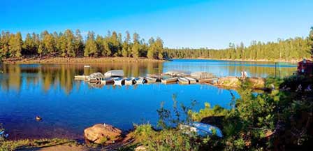
Location & Description. Although a relatively small lake at 55 acres, Woods Canyon Lake is one of the most accessible of the Rim lakes and has a very scenic setting in a heavily forested area on the edge of the Mogollon Rim. The landscape is simply gorgeous and at an elevation of about 7,500 feet, visitors can expect very pleasant temperatures in the spring and summer months. It's four season territory with a cool, colorful autumn and cold and snowy winters, like most White Mountain Lakes.
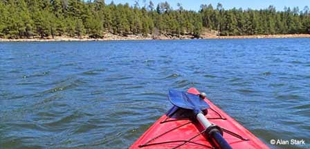
 Woods Canyon Lake. © Alan Stark
The lake is located about 30 miles east of Payson, Arizona and is very close to its sister-lake, Willow Springs Lake. Small, but mighty, Woods Canyon has produced some trophy size Rainbows and Brown Trout including a 10 pound Brownie caught in 1999. Access is restricted in the winter when roads are closed at the highway due to snow, generally from December to early April.
Why Visit Woods Canyon Lake
Visitors are drawn to Woods Canyon Lake for its stunning scenery and easy access from central Arizona. Its combination of fishing, boating, and forest recreation makes it a favorite weekend destination for those seeking a refreshing escape into the mountains.
Lake Size. Woods Canyon Lake has a water surface of about 55 acres, an average depth of 25 feet and a maximum depth of about 40 feet. This is a deep canyon style lake.
Fish Variety. Rainbow and Brown Trout thrive here and there are some really big ones. The state stocks catchable size trout every week from May through September.
Fishing at Woods Canyon Lake
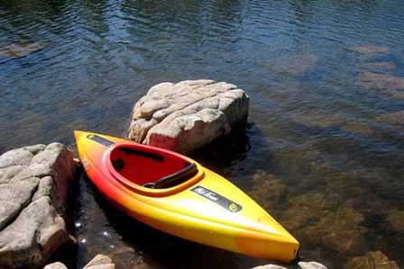
Woods Canyon Lake is one of the most popular trout fishing lakes on the Mogollon Rim, especially from late spring through early fall when access is open and rainbow trout are regularly stocked. Anglers fish from shore, small boats, kayaks and the dam area, with rainbow trout being the main target. Brown trout are also found in the lake, and some larger fish are caught by anglers using lures that imitate crayfish or small baitfish.
- Best fish species: Rainbow trout and brown trout.
- Best trout season: May through September, especially after regular trout stockings.
- Best methods: PowerBait, worms, small spoons, spinners, Kastmasters and trolling from small boats.
- Fishing tip: In warmer summer weather, trout often hold deeper, but avoid fishing too deep because the lake can stratify.
Boating at Woods Canyon Lake
Boat motors are restricted to electric motors only.
Camping, Hiking & Amenities
There is a picnic area and restrooms at the lake along with a boat ramp. A concessionaire at the lake rents boats, sells fishing licenses, sells bait and tackle and carries well-stocked items in its country store. RV campers will find a dump station about a mile from the lake. There are four fee-based campgrounds nearby including the most popular Spillway Campground which is the closest to the lake. It has 26 camp sites, each accommodating trailers up to 16 feet long. Conveniences at Spillway include a campground host, drinking water, picnic tables, barrier-free restrooms and fire rings.
Aspen Campground, along Forest Road 105, is much larger with 136 sites, and can accommodate trailers up to 32 feet long. It has the same amenities as Spillway. The Crook Campground is mainly a group camping area, with two loops and a total of 26 sites. Usually, one entire loop is reserved for a group. Each loop has a large ramada with picnic tables.
Mogollon Campground, located along Forest Road 300, has 26 units accommodating trailers up to 32 feet. Amenities are the same as at Spillway Campground. No reservations are taken for this campground. Camping fees at most of the campgrounds start at $16 per vehicle per night. The campgrounds are open from April 15 to October 15, weather permitting. Get more camping information and reserve a site by calling 1-877-444-6777.
Best Time to Visit Woods Canyon Lake
- Spring: Late spring is a great time for trout fishing as roads reopen, campgrounds begin operating and stocked fish become active.
- Summer: Summer is the busiest season, with cool mountain weather, boating, kayaking, camping, fishing and family day trips from Phoenix and Payson.
- Fall: Fall brings cooler air, changing colors, fewer crowds and good fishing conditions, especially for anglers targeting larger trout.
- Winter: Winter access is usually restricted because roads close due to snow, generally from December into early April.
Payson Area & Rim Lakes
- Bear Canyon Lake - 60 acres
- Black Canyon Lake - 78 acres
- Blue Ridge Reservoir - 70 acres
- Chevelon Canyon Lake - 208 acres
- Knoll Lake - 75 acres
- Willow Springs Lake - 158 acres
- Woods Canyon Lake - 55 acres
Directions To Woods Canyon Lake
From Scottsdale and Phoenix. Take Highway 87 (Beeline Highway) northeast to Payson AZ and then Highway 260 East to Forest Road 300 (Rim Road). Then turn north onto paved Forest Road 105 and proceed about a mile to the lake. The lake is about 30 miles east of Payson AZ.
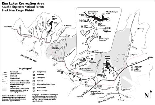
Map of Woods Canyon Lake
The map shows how to get to Woods Canyon Lake from Payson AZ and the locations of nearby campgrounds, hiking trails, picnic spots, scenic overlooks, and the Mogollon Rim Visitor Information Center. The map also shows the directions to Willow Springs Lake and Bear Canyon Lake on the Mogollon Rim within Apache Sitgreaves National Forest. Click on the location map to see an enlarged downloadable view.
Woods Canyon Lake FAQs
Where is Woods Canyon Lake?
Woods Canyon Lake is located on the Mogollon Rim about 30 miles east of Payson, Arizona, near Highway 260 and Forest Road 300.
What kind of fish are in Woods Canyon Lake?
Woods Canyon Lake is best known for rainbow trout and brown trout. Rainbow trout are regularly stocked during the main fishing season.
Can you boat on Woods Canyon Lake?
Yes, boating is allowed on Woods Canyon Lake, but motors are restricted to electric motors only.
Can you camp at Woods Canyon Lake?
Yes, several fee-based campgrounds are located near Woods Canyon Lake, including Spillway, Aspen, Crook and Mogollon campgrounds.
Is Woods Canyon Lake open in winter?
Winter access is generally restricted because roads often close due to snow, usually from December through early April.
More Information
Apache-Sitgreaves National Forest
Black Mesa Ranger District
2748 East AZ 260
Overgaard, Arizona 85933
Black Mesa Ranger District
(928) 535-7300
Related Reading and Area Attractions
Payson Area Lakes
Christopher Creek Area
Strawberry Arizona
Payson AZ Cabin Rentals
Tonto Natural Bridge
Phoenix Area Lakes
Apache Lake
Bartlett Lake
Canyon Lake
Lake Pleasant
Roosevelt Lake
Saguaro Lake
Tempe Town Lake
Urban Lakes
Payson Area Lakes
Bear Canyon Lake
Black Canyon Lake
Blue Ridge Reservoir
Chevelon Canyon Lake
Knoll Lake
Willow Springs Lake
Woods Canyon Lake
White Mountains Lakes
Becker Lake
Big Lake
Crescent Lake
Fool Hollow Lake
Hawley Lake
Luna Lake
Lyman Lake
Rainbow Lake
Show Low Lake
Woodland Lake