Lake Havasu City Arizona Map & Directions
Reviewed and updated by AZ Leisure Staff Writers on
Lake Havasu City is located in western Arizona on the eastern shore of Lake Havasu, with Arizona State Route 95 serving as the city's primary north-south highway. Interstate 40 is about 18 miles north of the city, while Interstate 10 can be reached to the south through Parker and the lower Colorado River corridor. Use the interactive map below to locate Lake Havasu City and plan driving routes from Phoenix, Las Vegas, Southern California and other Southwest destinations.
- Interactive Lake Havasu City Map
- Where Is Lake Havasu City?
- Directions From Phoenix
- Directions From Las Vegas
- Directions From California
- Driving Times & Distances
- Nearest Major Airports
- Getting Around Lake Havasu City
- Official Lake Havasu Maps
- Road Trip Planning Tips
- Lake Havasu City Map FAQ
Interactive Lake Havasu City Map
Where Is Lake Havasu City Arizona?
Lake Havasu City is located in western Mohave County, Arizona, on the eastern shore of Lake Havasu. Arizona State Route 95 runs through the city and provides the primary highway connection north toward Interstate 40 and south toward Parker and Interstate 10.
Lake Havasu City is approximately 18 miles south of Interstate 40 and about 65 miles north of Interstate 10 by way of Arizona Highway 95. Its location along the lower Colorado River corridor makes it accessible from Phoenix, Las Vegas, Southern California, Kingman, Parker and Bullhead City.
Directions From Phoenix To Lake Havasu City
From the Phoenix area, travel west on Interstate 10 toward Quartzsite, then use US Highway 95 north toward Parker. Continue through the Parker area and follow Arizona State Route 95 north to Lake Havasu City.
The trip is generally about three hours from the Phoenix area under normal driving conditions. Traffic, construction, weather and your exact starting point can change travel time, so check current navigation and highway conditions before departure.
Directions From Las Vegas To Lake Havasu City
From Las Vegas, travel south toward Kingman using the current US Highway 93 corridor, then continue toward Interstate 40. Travel west on I-40 to the Arizona State Route 95 connection and follow SR 95 south into Lake Havasu City.
Lake Havasu City is approximately 2½ hours south of Las Vegas under normal driving conditions. Check current navigation before departure because construction, traffic and highway conditions can affect the preferred route.
Directions From Southern California To Lake Havasu City
Travelers approaching from Southern California commonly reach Lake Havasu City through either the Interstate 40 corridor or Interstate 10 and the lower Colorado River corridor, depending on their starting point. From the Los Angeles area, the trip generally takes about four to five hours.
Because Southern California routes vary substantially by city and traffic conditions, use current navigation rather than relying on a single fixed route. Confirm that your destination is Lake Havasu City, Arizona rather than a location on the California side of Lake Havasu.
Approximate Driving Times To Lake Havasu City
- Phoenix: Approximately 3 hours
- Las Vegas: Approximately 2½ hours
- Los Angeles Area: Approximately 4 to 5 hours
- Interstate 40: Approximately 18 miles north of Lake Havasu City
- Interstate 10: Approximately 65 miles south via the Parker area
Driving times are approximate and can change because of traffic, construction, weather, events and the exact starting point.
Major Airports Near Lake Havasu City
- Harry Reid International Airport - Las Vegas: Approximately 150 miles and about 2½ hours by car
- Phoenix Sky Harbor International Airport: Approximately 210 miles and about 3 hours by car
- Los Angeles International Airport: Approximately 315 miles and about 5 hours by car
Lake Havasu City also has a local municipal airport and charter aviation options, but scheduled airline travelers generally use Las Vegas or Phoenix for the broadest selection of flights.
Getting Around Lake Havasu City
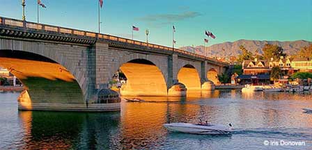
Arizona State Route 95 is the principal highway through Lake Havasu City, while major local streets provide access to the London Bridge area, the Island, waterfront parks, marinas, shopping districts and residential neighborhoods.
Visitors should use the interactive map or current city map when navigating locally because construction, street projects and temporary detours can affect travel. Lake Havasu City also operates a demand-responsive public transportation service known as LHC DIRECT.
Official Lake Havasu City Maps
Go Lake Havasu provides downloadable maps for visitors who want more detail than the general interactive map above. Current map resources include a Lake Havasu City directional map as well as boating, camping, trail and lake-recreation maps.
- Lake Havasu City directional map
- Points of interest and recreation
- Marinas and boat-launch ramps
- Fishing docks
- Lighthouses
- Designated swimming areas
- Multi-use trails
- Boat-in campsites and shoreline facilities
View official Lake Havasu map downloads.
Lake Havasu City Road Trip Tips
- Check Road Conditions: Review current Arizona highway information before long-distance travel
- Use Current Navigation: Construction and detours can temporarily change the preferred route
- Fuel Before Remote Stretches: Western Arizona includes long desert highway segments between communities
- Carry Water: Keep drinking water in the vehicle, especially during summer
- Watch Summer Temperatures: Extreme desert heat can make vehicle problems more serious
- Allow Event Traffic Time: Major Lake Havasu events can increase congestion around the waterfront and London Bridge
- Confirm Your Destination: Lake Havasu City is in Arizona; other Lake Havasu destinations are located on the California side
Official Lake Havasu City Map & Travel Information
- Official Lake Havasu Maps
- Go Lake Havasu Visitor Information
- Lake Havasu City Government
- Arizona Department Of Transportation
Lake Havasu City Map & Directions FAQ
Where is Lake Havasu City Arizona?
Lake Havasu City is located in western Mohave County, Arizona on the eastern shore of Lake Havasu and along Arizona State Route 95.
Is Lake Havasu City in Arizona or California?
Lake Havasu City is in Arizona. Lake Havasu itself extends along the Arizona-California border, but the city is located on the Arizona side of the lake.
How far is Lake Havasu City from Interstate 40?
Lake Havasu City is approximately 18 miles south of Interstate 40 via Arizona State Route 95.
How far is Lake Havasu City from Interstate 10?
Lake Havasu City is approximately 65 miles north of Interstate 10 through the Parker area and Arizona Highway 95 corridor.
How long is the drive from Phoenix to Lake Havasu City?
The drive from the Phoenix area is generally about three hours, depending on the exact starting point, traffic and road conditions.
How long is the drive from Las Vegas to Lake Havasu City?
The drive from Las Vegas is generally about 2½ hours under normal conditions.
How long is the drive from Los Angeles to Lake Havasu City?
The drive from the Los Angeles area is generally about four to five hours, depending on traffic and the exact starting point.
What highway goes through Lake Havasu City?
Arizona State Route 95 is the primary highway serving Lake Havasu City and connects the community with Interstate 40 to the north and Parker and Interstate 10 to the south.
What major airport is closest to Lake Havasu City?
Harry Reid International Airport in Las Vegas is approximately 150 miles from Lake Havasu City. Phoenix Sky Harbor International Airport is approximately 210 miles away.
Can I download a Lake Havasu City map?
Yes. Go Lake Havasu provides downloadable city, boating, camping and recreation maps showing points of interest, marinas, ramps, fishing docks, lighthouses and other visitor resources.
Is there public transportation in Lake Havasu City?
Yes. Lake Havasu City operates LHC DIRECT, a shared public microtransit service with flexible routing based on trip demand.
Should I rely on printed directions to Lake Havasu City?
Printed directions can be useful for general planning, but current navigation and highway information are preferable because construction, road work, detours and traffic conditions can change.
Related Lake Havasu City Interest
Lake Havasu City
Lake Havasu ATV Rentals
Lake Havasu Bed & Breakfasts
Lake Havasu Boat Rentals
Lake Havasu Pictures
Lake Havasu Fishing
Lake Havasu Horseback Riding
Lake Havasu Weather Info
London Bridge
London Or Lake Havasu
Along The Colorado River
Colorado River Lakes
Lake Powell
Lake Mead
Lake Mohave
Lake Havasu