

West Fork Oak Creek Trail Map, Directions & Hiking Information
Last updated on .
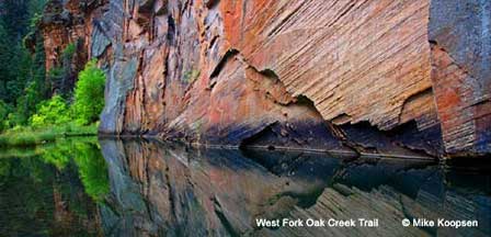
The Oak Creek Canyon Trail, including the popular West Fork Trail, is one of Arizona’s most scenic and rewarding hiking destinations. Located in the heart of Oak Creek Canyon between Sedona and Flagstaff, this trail winds through towering canyon walls, lush forest, and crystal-clear creek crossings that create a unique desert-meets-mountain landscape. Known for its vibrant fall colors, shaded pathways, and peaceful surroundings, the Oak Creek Canyon Trail offers a refreshing outdoor experience unlike anywhere else in Arizona. Whether you’re seeking a relaxing nature walk or a longer backcountry hike, this trail delivers some of the most picturesque scenery in the state.
Oak Creek Trail, Arizona
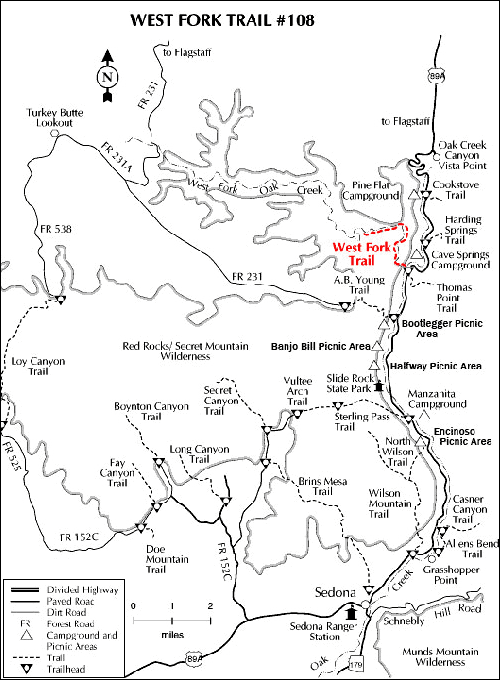
The West Fork Oak Creek Trail in Oak Creek Canyon is located just 9.5 miles north of Sedona, Arizona and 17.5 miles south of Flagstaff, Arizona on Highway 89A. It is open all year. Regular hours are 9:00 AM to 8:00 PM with an onsite host at the trailhead. Generally the gate is open by 8:00 AM with a self-pay system. At the time this article was written, the fee was $2.00 per person.
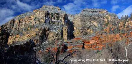
Why People Enjoy The West Fork Oak Creek Trail
Visitors are drawn to Oak Creek Canyon for its cool temperatures, natural beauty, and wide range of outdoor activities. Flowing water, shaded hiking trails, and abundant wildlife make it an ideal escape from the desert heat, especially during spring, summer, and fall. Many enjoy wading in the creek, photographing the canyon’s dramatic cliffs, or exploring nearby picnic areas and scenic viewpoints along Highway 89A. The peaceful atmosphere, combined with easy access from both Sedona and Flagstaff, makes Oak Creek Canyon a favorite destination for hikers, families, and nature lovers looking to unwind in a stunning natural setting.
The West Fork Trailhead is "Call of the Canyon" picnic area which is operated by an onsite concessionaire. There are 6 picnic tables and public toilets with a public parking area. There is no drinking water. At peak season, the parking lot can get full early on weekends. The best time to picnic or hike is during weekdays when parking areas and trails are typically less crowded.
GPS Coordinates: N34° 59' 25.3314", W111° 44' 14.244"
Best Time To Hike West Fork Trail
West Fork Trail can be enjoyed year-round, but spring, summer, and fall are the most popular seasons for hiking. Spring brings flowing creek water and mild temperatures, while summer offers shaded hiking conditions that are cooler than many lower desert areas in Arizona. Fall is especially popular because of the colorful changing leaves throughout Oak Creek Canyon. Winter hikes can also be beautiful, although icy trail sections and cold creek crossings are possible after storms.
- Spring: Comfortable temperatures, flowing water, and blooming canyon vegetation.
- Summer: Cooler hiking conditions thanks to shaded canyon walls and creek access.
- Fall: Peak season for colorful autumn leaves and scenic photography.
- Winter: Quiet hiking conditions with occasional snow and icy creek crossings.
What To Expect On The West Fork Trail
The West Fork Trail is considered one of the most scenic hikes in Arizona and includes multiple shallow creek crossings, shaded forest areas, and dramatic canyon scenery. Most visitors hike only part of the trail before turning around, while experienced hikers often continue deeper into the canyon for a longer adventure. Comfortable hiking shoes or water-resistant footwear are recommended because creek crossings are common throughout portions of the trail.
- Creek Crossings: Expect multiple crossings depending on seasonal water flow.
- Shaded Hiking: Large trees and canyon walls help keep temperatures cooler.
- Photography: Popular for landscape photography and fall foliage.
- Wildlife Viewing: Birds, deer, squirrels, and other wildlife are occasionally seen along the trail.
Parking, Fees & Trailhead Information
The West Fork Trailhead parking area can fill quickly during weekends, holidays, and peak fall foliage season. Arriving early in the morning is recommended, especially during busy months. Parking fees and operating hours may change seasonally, so visitors should verify current information before traveling to the trailhead.
- Location: Highway 89A in Oak Creek Canyon between Sedona and Flagstaff.
- Parking: Public parking available at the Call of the Canyon picnic area.
- Facilities: Restrooms and picnic tables available onsite.
- Water: No drinking water available at the trailhead.
Location Map
Nearby Attractions Around Oak Creek Canyon
Many visitors combine a hike along West Fork Trail with other nearby attractions in Sedona and Oak Creek Canyon. Scenic drives, picnic areas, swimming spots, and red rock viewpoints are all located within a short drive of the trailhead.
- Slide Rock State Park: Popular swimming and creek recreation area along Highway 89A.
- Oak Creek Canyon Vista Point: Scenic overlook with panoramic canyon views.
- Sedona Red Rock Country: Shopping, restaurants, jeep tours, and hiking trails.
- Flagstaff: Mountain town offering cooler temperatures and additional outdoor recreation.
FAQ
Where is the West Fork Oak Creek Trail located?
The West Fork Oak Creek Trail is located in Oak Creek Canyon along Highway 89A between Sedona and Flagstaff, Arizona.
Is West Fork Trail considered an easy hike?
Most visitors consider West Fork Trail a moderate hike because of uneven terrain and multiple creek crossings, although shorter sections are suitable for many casual hikers.
Does West Fork Trail have creek crossings?
Yes. Depending on water levels and how far you hike into the canyon, there can be numerous shallow creek crossings along the trail.
When is the best time to visit West Fork Trail?
Spring and fall are considered the best times to visit because temperatures are comfortable and the scenery is especially beautiful during changing seasons.
Are dogs allowed on the West Fork Trail?
Dogs are generally allowed on the trail if kept on a leash, but visitors should verify current forest regulations before visiting.
Is parking available at the trailhead?
Yes. Public parking is available at the Call of the Canyon picnic area near the West Fork Trailhead, although parking can fill early during busy weekends and holidays.
How long is the West Fork Trail hike?
Many hikers travel only part of the trail before returning, while others continue several miles deeper into Oak Creek Canyon depending on conditions and experience level.
Is there drinking water at the trailhead?
No. Visitors should bring their own drinking water because potable water is not available at the trailhead.
Related Reading
West Fork Oak Creek Trail Overview
Oak Creek Canyon Photos By Mike Koopsen
Other Oak Creek Canyon Hiking Trails
West Fork Detail: Coconino National Forest
Red Rock Ranger District
P.O. Box 20429
8375 State Route 179
Sedona, AZ 86341
(928) 203-2900
Always call ahead for possible closures.
Related Sedona Interest
Sedona Arizona
Map & Directions Oak Creek Trail
Oak Creek Canyon Map & Directions
Oak Creek Canyon Photos By Koopsen
Oak Creek Canyon Vista Point
Sedona Aerial Photos By Koopsen
Sedona Winter Photos By Koopsen
Verde Canyon Railroad
The Wonder Of Sedona & Oak Creek
Sedona-Oak Creek Canyon
Sedona Arizona
Oak Creek Canyon
Arizona Route 66
Map & Directions
Weather & Climate
Sedona Pictures
Things To Do
Public Golf Courses
Grand Canyon Tours
West Fork Trail
Desert Canyon Drive
Sedona Museums
Events & Festivals
Horseback Riding
Area Attractions
Palatki Indian Ruins
Montezuma Castle
Montezuma Well
Grand Canyon South Rim
Sycamore Canyon
Slide Rock State Park
Grand Canyon Railway
Chapel of the Holy Cross
Oak Creek
Nearby Towns
Flagstaff Arizona
Jerome Arizona
Cornville Arizona
Williams Arizona
Cottonwood Arizona
Sedona Articles
Native American History
Vortex Visions
Mystical Vortexes
Enchantment Resort
Credit The Sinagua
Where To Stay
Cabins & Lodges
RV Parks & Campgrounds
Bed and Breakfast
Sedona Vacation Rentals
Sedona Timeshares