

Piestewa Peak Hiking & Summit Trail 300
Updated by AZ Leisure Staff Writers on
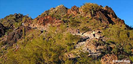
 View From The Top of Piestewa Peak. © Robert Body
Piestewa Peak rises to an elevation of 2,608 feet in the Phoenix Mountains Preserve and is one of the best-known hiking landmarks in central Phoenix. The challenging Piestewa Peak Summit Trail climbs steeply through Sonoran Desert terrain to panoramic views across the Phoenix metropolitan area. Its convenient urban location makes the trail popular with local hikers and visitors, but the short distance should not be underestimated—the City of Phoenix rates the Summit Trail as extremely difficult because of its steep, rocky terrain and sustained elevation gain.
- Piestewa Peak Overview
- Summit Trail 300
- Trail Difficulty
- Summit Views
- Name & History
- Hours & Parking
- Directions
- Heat Safety
- Other Trails
- Hiking Tips
- FAQ
Piestewa Peak In The Phoenix Mountains Preserve
Piestewa Peak is located in the Phoenix Mountains Preserve near the center of the Phoenix metropolitan area. The mountain rises prominently above surrounding neighborhoods and provides expansive views toward downtown Phoenix, Camelback Mountain, South Mountain and other desert ranges. Its central location makes it one of the most accessible strenuous summit hikes for visitors staying in Phoenix or Scottsdale.
Piestewa Peak Summit Trail 300
- Distance: Approximately 1.2 miles to the summit, or about 2.4 miles round trip.
- Elevation gain: Approximately 1,200 feet.
- Difficulty: Extremely difficult.
- Route: Steep out-and-back summit hike with switchbacks, rock, gravel and constructed steps.
- Trailhead: Access begins from the 302 Trailhead area at 2701 E. Piestewa Peak Drive.
- Facilities: Parking, drinking water and restrooms are available near the trailhead.
- Dogs: Dogs are prohibited year-round on the Summit Trail.
- Bicycles: Mountain biking is prohibited on the Summit Trail.
How Difficult Is The Piestewa Peak Hike?
Piestewa Peak Summit Trail is short but strenuous. The climb becomes progressively steeper as hikers approach the summit, with rocky footing, switchbacks and numerous step-like sections. The roughly 1,200 feet of elevation gain occurs over little more than a mile, making the ascent physically demanding and the descent hard on knees and ankles. Hikers should choose a pace appropriate for their fitness level and turn around if heat, fatigue or limited water becomes a concern.
Views From Piestewa Peak
The summit provides 360-degree views across much of the Phoenix metropolitan area and surrounding Sonoran Desert mountains. Depending on visibility, hikers can see downtown Phoenix, Camelback Mountain, South Mountain, neighboring Phoenix Mountains and distant desert ranges. Sunrise and late-afternoon light can be especially scenic, although hikers should plan their descent carefully if hiking near sunset.
How Piestewa Peak Got Its Name
Piestewa Peak was formerly known as Squaw Peak. The mountain was renamed in honor of U.S. Army soldier Lori Piestewa, a member of the Hopi Tribe who was killed during the Iraq War in 2003. The U.S. Board on Geographic Names formally approved Piestewa Peak as the federal geographic name in 2008. Today, Piestewa Peak is the appropriate name to use for the mountain and hiking area.
Piestewa Peak Hours & Parking
Piestewa Peak trails are currently open from 5 a.m. to 11 p.m. Normal trailhead parking and entrance hours are 5 a.m. to 7 p.m. From June 1 through September 30, the Piestewa Peak Trailhead parking entrance remains open until 9 p.m. Parking can fill quickly during mornings, weekends and periods of cooler hiking weather, so arriving early is recommended.
Directions To Piestewa Peak Summit Trail
The primary Piestewa Peak trailhead is located at 2701 E. Piestewa Peak Drive in Phoenix. From the trailhead area, hikers begin from the 302 Trailhead and follow the signed route toward the Piestewa Peak Summit Trail. Because Phoenix street configurations and navigation routes can change, use current navigation directions to the Piestewa Peak Trailhead rather than relying on older references to Squaw Peak Drive.
Parking, restrooms and drinking water are available near the trailhead. Parking is limited and can fill during popular hiking periods, particularly on weekends and during the cooler months.
Piestewa Peak Heat Safety
Extreme heat is one of the most serious hazards on Piestewa Peak. During warm weather, hike early, carry plenty of water and avoid beginning a strenuous climb when temperatures are already high. The exposed desert trail offers limited relief from the sun, and heat illness can develop quickly even among experienced hikers.
When the National Weather Service issues an Extreme Heat Warning, trails associated with the Piestewa Peak Trailhead are currently closed from 8 a.m. to 5 p.m. Check City of Phoenix trail alerts and the weather forecast before leaving for the trailhead.
Other Trails Near Piestewa Peak
Visitors who do not want to climb the Summit Trail have several alternatives within the Piestewa Peak and Dreamy Draw trail system.
- Piestewa Peak Freedom Trail: A difficult 3.7-mile route around the base of the peak with approximately 720 feet of elevation change.
- Piestewa Peak Nature Trail: A moderate 1.4-mile trail with approximately 180 feet of elevation change and good Sonoran Desert scenery.
- Ruth Hamilton Trail: A moderate-to-difficult 0.9-mile trail with approximately 430 feet of elevation change.
- Quartz Ridge Trail: A moderate 1.7-mile route with approximately 500 feet of elevation change and views toward downtown Phoenix and Camelback Mountain.
- Dreamy Draw Nature Trail: A moderate 1.5-mile loop through desert washes and native Sonoran vegetation.
Piestewa Peak Hiking Tips
- Start early, particularly from late spring through early fall.
- Carry more water than you think you will need.
- Wear sturdy hiking shoes with good traction.
- Use sunscreen, sunglasses and sun-protective clothing.
- Do not underestimate the trail because of its short distance.
- Yield to uphill hikers when descending narrow sections.
- Stay on designated trails and avoid shortcutting switchbacks.
- Leave dogs at home because they are prohibited on the Summit Trail.
- Check current trail closures and heat warnings before leaving home.
- Turn around before reaching the summit if heat, fatigue or limited water becomes a concern.
Piestewa Peak Hiking FAQ
How Long Is The Piestewa Peak Summit Trail?
The Summit Trail is approximately 1.2 miles from the trailhead area to the summit, making the hike about 2.4 miles round trip.
How Difficult Is Piestewa Peak?
The City of Phoenix rates the Piestewa Peak Summit Trail as extremely difficult because of its steep grade, rocky terrain, switchbacks and approximately 1,200 feet of elevation gain.
How High Is Piestewa Peak?
Piestewa Peak reaches an elevation of approximately 2,608 feet above sea level.
How Much Elevation Do You Gain Hiking Piestewa Peak?
The Summit Trail gains approximately 1,200 feet between the trailhead area and summit.
How Long Does It Take To Hike Piestewa Peak?
Hiking time varies significantly with fitness, weather, crowding and rest stops. Many visitors should allow roughly 1.5 to 3 hours for the round trip rather than planning around a specific fast hiking time.
Where Is The Piestewa Peak Trailhead?
The primary trailhead is located at 2701 E. Piestewa Peak Drive in Phoenix within the Phoenix Mountains Preserve.
What Are The Hours At Piestewa Peak?
Trail hours are currently 5 a.m. to 11 p.m. Normal parking and entrance hours are 5 a.m. to 7 p.m., with the Piestewa Peak Trailhead parking entrance open until 9 p.m. from June 1 through September 30.
Are Dogs Allowed On Piestewa Peak?
Dogs are prohibited year-round on the Piestewa Peak Summit Trail.
Are Bikes Allowed On The Summit Trail?
No. Mountain biking is prohibited on the Piestewa Peak Summit Trail.
Does Piestewa Peak Close During Extreme Heat?
Yes. When the National Weather Service issues an Extreme Heat Warning, trails associated with the Piestewa Peak Trailhead are closed from 8 a.m. to 5 p.m.
Is There Water At The Piestewa Peak Trailhead?
Yes. Drinking water and restrooms are available near the main trailhead, but hikers should still bring adequate water for the hike.
What Can You See From The Top Of Piestewa Peak?
The summit offers panoramic views across Phoenix and surrounding mountains, including downtown Phoenix, Camelback Mountain, South Mountain and other parts of the Sonoran Desert.
Related Phoenix Interest
Phoenix Arizona
Greater Phoenix Map
Rawhide Western Town
Roosevelt Lake Map & Directions
South Mountain Park
Phoenix To South Rim
Greater Phoenix Things To Do
Hiking Papago Park
Phoenix Dude Ranches
Phoenix Events & Festivals
Desert Botanical Garden
Phoenix Weather Info
Phoenix Boat Tours
Mystery Castle
Phoenix Horseback Riding
Camelback Mountain
Phoenix Area Museums
Phoenix Zoo
Phoenix Arts & Theatre
Japanese Friendship Garden
Phoenix Fishing Guides
Phoenix Area Attractions
Metro Phoenix