Grand Canyon South Rim Directions & Driving Routes
Reviewed and updated by AZ Leisure Staff Writers on .
Driving to the Grand Canyon South Rim is relatively straightforward, with several scenic routes leading to Grand Canyon Village and the park's two South Rim entrances. Most visitors arrive from Williams, Flagstaff, Sedona, Phoenix, Scottsdale or Las Vegas. Use the maps and driving directions below to compare routes to the South Entrance near Tusayan and the Desert View Entrance on the canyon's east side, and allow extra travel time during busy seasons and winter weather.

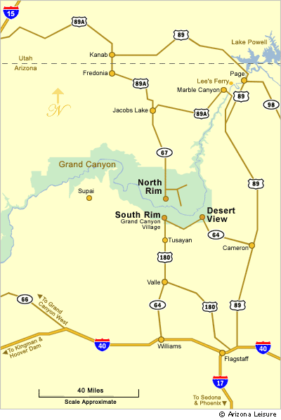
Visitors can reach the South Rim through the South Entrance near Tusayan or the Desert View Entrance on the east side of the park. The two areas are connected by the approximately 25-mile Desert View Scenic Drive, which follows the South Rim between Grand Canyon Village and Desert View and provides access to several scenic overlooks along the way.
- South Rim Maps
- Driving Directions
- Routes From Major Cities
- South Rim Entrances
- Winter Driving
- Driving & Travel Tips
- FAQ
Grand Canyon South Rim Maps

Driving Routes To The South Rim
From Flagstaff, Arizona
The Grand Canyon South Rim is approximately 80 miles from Flagstaff, depending on the route. Three common approaches are available:
- Via Williams: Take I-40 west to Williams, then Arizona Highway 64 north to the South Entrance.
- Via Highway 180: Take US Highway 180 northwest from Flagstaff to Valle, then Highway 64 north to the South Entrance.
- Via Cameron and Desert View: Take US Highway 89 north to Cameron, then Highway 64 west to the Desert View Entrance.
From Williams, Arizona
Williams is approximately 60 miles south of the Grand Canyon South Rim. Take Arizona Highway 64 north from Williams through Valle and Tusayan to the South Entrance. This is one of the most direct and commonly traveled routes to Grand Canyon Village.
From Sedona, Arizona
The South Rim is approximately 115 to 120 miles from Sedona, depending on the route. Take Highway 89A north through scenic Oak Creek Canyon to Flagstaff, then continue toward the South Rim using one of the Flagstaff routes described above.
From Phoenix & Scottsdale
The Grand Canyon South Rim is approximately 225 to 235 miles from the Phoenix and Scottsdale area. Take I-17 north toward Flagstaff, then continue to the South Rim via Williams and Highway 64, Highway 180 and Highway 64, or US 89 through Cameron to the Desert View Entrance.
From Las Vegas, Nevada
The Grand Canyon South Rim is approximately 275 to 280 miles from Las Vegas. A common route follows US Highway 93 south toward Kingman, then I-40 east to Williams and Highway 64 north through Tusayan to the South Entrance. Travel time varies with traffic, road conditions and stops along the way.
Winter Driving To The Grand Canyon South Rim
The Grand Canyon South Rim is open year-round, but winter storms can bring snow, ice and hazardous driving conditions to northern Arizona. Roads may become snow-covered or temporarily restricted during severe weather. Before leaving, check current highway conditions through AZ511 and check Grand Canyon National Park information for current park conditions. Allow additional travel time during winter storms and be prepared for rapidly changing weather.

South Rim Driving & Travel Tips
- Allow extra driving time during summer, holiday weekends and other busy travel periods.
- Check road and weather conditions before traveling during winter or early spring.
- Fill your fuel tank before entering more remote stretches of northern Arizona.
- Use the South Entrance when approaching from Williams and the Desert View Entrance when approaching from Cameron and US Highway 89.
- Download or carry a map in case cellular service becomes limited during portions of the drive.
- Plan time for scenic stops if entering through Desert View and driving toward Grand Canyon Village.
Plan Your Grand Canyon South Rim Visit
Grand Canyon South Rim Directions FAQ
What is the main entrance to the Grand Canyon South Rim?
The South Entrance near Tusayan is the primary entrance for travelers arriving from Williams, Phoenix, Scottsdale and Las Vegas. It provides convenient access to Grand Canyon Village and the main South Rim visitor areas.
Can you enter the South Rim from the east?
Yes. The Desert View Entrance on the east side of the South Rim is reached from US Highway 89 and Cameron via Arizona Highway 64. From Desert View, Highway 64 continues west along the rim toward Grand Canyon Village.
How far is the Grand Canyon South Rim from Flagstaff?
The South Rim is approximately 80 miles from Flagstaff, depending on the route and entrance used. Travelers can approach through Williams, Valle or Cameron.
How far is the Grand Canyon South Rim from Phoenix?
The South Rim is approximately 225 to 235 miles from the Phoenix area, depending on the starting point and route. Most travelers drive north on I-17 toward Flagstaff before continuing to the Grand Canyon.
How far is the Grand Canyon South Rim from Las Vegas?
The South Rim is approximately 275 to 280 miles from Las Vegas. A common route travels through Kingman and Williams before following Highway 64 north to the South Entrance.
Can you drive to the Grand Canyon South Rim in winter?
Yes. The South Rim is open year-round, but snow and ice can affect roads during winter storms. Check current highway and park conditions before traveling and allow additional time when winter weather is expected.
Which entrance is best for Desert View Scenic Drive?
The Desert View Entrance is the best choice when approaching the Grand Canyon from Cameron and US Highway 89. From the entrance, Desert View Scenic Drive follows the South Rim west toward Grand Canyon Village with access to several scenic overlooks.
Which South Rim Entrance Should You Use?
The South Entrance near Tusayan is the primary approach for visitors arriving from Williams, Phoenix, Scottsdale and Las Vegas. It provides convenient access to Grand Canyon Village, the visitor center and many of the South Rim's most popular viewpoints.
The Desert View Entrance is reached from US Highway 89 and Cameron via Highway 64. It can be a convenient approach for travelers arriving from areas east of the Grand Canyon and provides access to Desert View and the scenic overlooks along Desert View Scenic Drive before reaching Grand Canyon Village.
Related Travel Planning Information
Average South Rim Monthly Temperature Chart
RV Parks Near The South Rim
Grand Canyon South Rim Campgrounds
The Spectacular Grand Canyon
Related Grand Canyon Interest
Grand Canyon National Park
Average Temperatures South Rim
Bright Angel Trail
Desert View Watchtower
Grand Canyon Camping
Grand Canyon Desert View Map
Grand Canyon Pictures By Koopsen
Grand Canyon Mule Ride
Grand Canyon Rafting
Grand Canyon South Rim Trail
Grand Canyon Winter Pictures By Koopsen
Grandview Point South Rim
Havasu Falls Pictures
Havasupai Indians
Lipan Point South Rim
Mather Point South Rim
Moran Point South Rim
Navajo Point South Rim
North Rim Map
Robert Body Grand Canyon Pictures
Shoshone Point South Rim
South Rim Grand Canyon Directions
South Rim Hours & Entrance Fees
Grand Canyon Summer Hiking
Trail Of Time South Rim
West Rim Map
Yaki Point Grand Canyon
Yavapai Point Geology Museum